
Clouds are collections of water droplets suspended in the air. A cloud is formed as the water vapour in the air condenses onto particles of dust or other water droplets. The water in a cloud weighs tonnes! It’s a good job that the droplets don’t have time to coalesce into great balls of water before they reach the ground, but I suppose that to insects a droplet is a huge ball of water, and able to cause havoc.
As anyone who has flown in an aircraft is likely to know, clouds are not well defined, and in fact they could be described as nebulous or hazy. From a mathematical point of view they are fractal and the fractal dimension (a measure of their fuzziness) varies depending on the cloud.

A common pastime on a summer’s day is to imagine shapes in the clouds. That one may look vaguely like a car, that one like a dog, and so on. But really, the only shape that clouds have is “cloud-like“.
There are many types of cloud shape, depending on the conditions and the altitude where the cloud is forming, but the usual depiction of a cloud generally looks like a cumulus type. This type forms the usual shape like piles of cotton wool in the sky, with mountain, canyons, and even castles.
There is always water vapour in the air, even if it doesn’t form clouds, although we cannot see it. As I said above, clouds are formed when this water vapour condenses on small particles in the air (and other conditions are right). Sometimes there are attempts to make rain by “seeding” a cloud with small particles to increase the rate of condensation and thus increasing the size of the water droplets.
At a certain size the droplets become to big to be buoyed up by the air and start to fall, picking up more moisture as they do. As I understand it, this cloud seeding process is limited in its success, but I may be wrong.
, rebuilt for cloud seeding...")
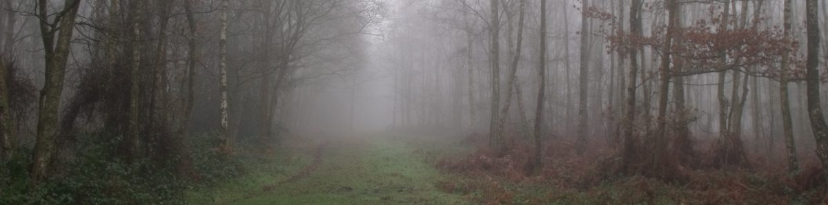
Clouds sometimes form at ground level, if the conditions are right, and then we call them fogs or mists. This often happens when light rain is falling and there is a lot of moisture in the air, but it can happen simply because the conditions are right.
Living where I do, I occasionally have reason to visit the local airport in Wellington. The airport is situation on a section of land that was brought up by a an earthquake, so that it is on a narrow stretch of land between two sets of hills. Over the hills to the East of the airport is the entrance to the Wellington Harbour.

On several occasions I have seen sea mist roll in from Cooks Strait to the South and extends tongues of thick mist over the airport and the Harbour entrance. This causes the airport to shut down until the conditions have cleared, spoiling the travel plans of hundreds of people.
Other clouds which are familiar to many are the stratus clouds. These clouds are layers which cover all or most of the sky under some conditions. They often presage rain or other forms of precipitation. Stratus clouds range from light to dark and in many cases might cause a drop in one’s spirits.

Certainly the dark stratus has that effect on me, and there is little that is more spectacular than breaking through a layer of cloud in a plane. The tops of the clouds will be brightly lit by the sun, and sometimes whorls or rivers of cloud can be seen from above.
The tops of the clouds can be quite lumpy and cumulus-like, and descending into the clouds is like descending into mountains and canyons and the lumps and bumps of the cloud can whizz past like scenery on a train, until the plane finally breaks through the greyer, darker ceiling of the cloud layer.

However, broken stratus clouds are the clouds which produce amazing sunsets as the sun drops through the layers and gaps in the clouds. Very often a beam of sun breaks through a stratus layer and lights up the water droplets or dust producing what looks like a column of light. These rays are known as crepuscular rays.
Add to that the amazing colours that result from the breakthrough sun beams and the dust and water droplets and sunsets can be very beautiful, even if the sun light is in fact refracting or reflecting from pollution in the air.

When the sun has gone below the horizon, it can still illuminate clouds above the horizon causing them to glow with an orange light, as the blue light is absorbed by the thick layer of atmosphere these rays which are almost tangential to the earth’s surface have to pass through.
Cumulus clouds are often sought out by glider pilots, since they are often formed by an up welling of air over a particularly warm piece of land. The up welling of air provides the glider pilot with extra lift, which allows them to travel vast distances, but a downside is that some clouds can be chaotic and turbulent. Birds will often guide a pilot to the up draughts there is no cloud.
Another totally different sort of cloud has appeared over recent years, and that is the Internet cloud. The Internet cloud is also somewhat nebulous, and allows us to take a photograph on one device (computer phone or tablet) and view it almost immediately on another device.
The cloud (often the Cloud) also allows for automatic backups for devices – if your device implodes or is lost or stolen, your data is safe. Mostly. For if you sync (synchronise) your device with the Cloud, and then delete a photograph, it will shortly be removed from the Cloud and lost.
To prevent data loss, you can backup to somewhere else on the cloud, so there are two (or more) cloud copies, or you can backup to a local computer or local storage, so that if you delete something by mistake you can always get it back. As anyone in the computer business will tell you, one backup is never enough!
